Over the past few decades, technology has changed many professions, including landscape architecture. It has altered landscape design processes, business, education, construction and many other aspects of the profession and its allied disciplines.
Artificial Intelligence (AI)
From what we have seen online and on social media, it appears that AI is mostly used for image visualisation to generate ideas, rough renders, and final concept renders. However, there is a wider range of capabilities of AI (apps & tools), including microclimate analysis, site analysis(ArcGIS, soil erosion modelling, planting design (Land Kit), pedestrian movement, generative design (plugins for Rhino & Grasshopper), materials and plant palettes, drone surveys, and more.
Although some started using AI in the mid-2010’s, it has only become more widely used in the past 3-4 years. The ability to be able to create images quickly and easily with a good resolution and references has increased in the past few years
AI Image from 2023 using Stable Diffusion 1.5 text to image


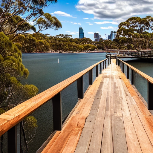
AI Image from 2026 – Using You.com (left) and Gemini (right) with a prompt to image – create an image of Sydney waterfront with a timber boardwalk going out to a rock island
The main issue at the moment is that a large amount of AI-generated imagery and designs are mediocre. Often described as “slop,” this emphasises the need for greater training and understanding of AI’s capabilities, and having a clearer intent and objectives when using AI to create images. Similarly, understanding the power of AI and the need to use prompts or a prompt series that will achieve the outcome required. When using AI, it also requires the user to take a critical eye and check the sources or answers for accuracy. The models are getting better, but there are still errors (often referred to as hallucinations).
AI is also being used for many other processes, including specification writing, contract reviews, report analysis and summaries, gap analysis, and other text-based tasks that can be automated. However, the content needs to be reviewed to ensure it meets the firm’s/client’s requirements and does not contain errors.
As discussed in my 2026 Landscape Trends article, there are many considerations for design firms and organisations regarding AI, including how comfortable they are with using it to generate ideas and concepts, as well as its possible environmental impacts.
Image Visualisation
Beyond using AI image generators (Midjourney, DALL-E, Stable Diffusion), many firms also use real-time rendering engines (D5, Enscape, etc.) to provide on-the-fly renders and perspectives, including fly-throughs. These start with a 3D model and render in real time, providing an instant rendering of the concept design.
There is also a mix of workflows for creating final visualisations, from traditional hand sketches to Photoshop renders of 3D wireframes to real-time or AI renders. There are myriad workflows and techniques for creating images, depending on your firm, the required look, and client expectations. At some point, technology comes into play, whether it’s scanning a hand-drawn sketch or using the latest AI rendering engine.
Image Capture (LIDAR, 3D Scanning, Photogrammetry)
There is an increase in the number of firms using drones, cameras, and phones to capture 3D models of sites or objects (rocks, wall finishes) for use in design concepts and construction documents (existing walls or repurposed materials, e.g., rocks). Using image capture can speed up data collection (trees, walls, topography) and make construction documents more legible and, in some cases, more accurate. Although it can be easily achieved, it takes some training and trial and error to get good results.
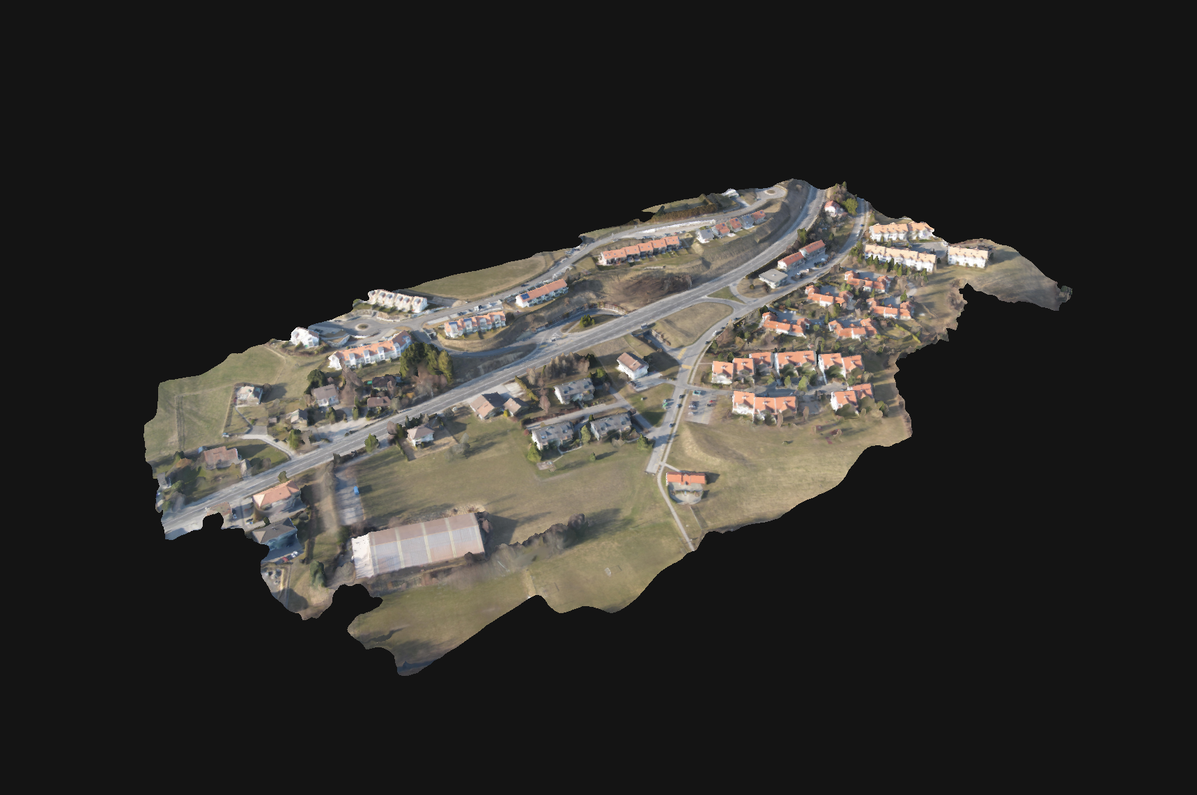
Also, the use of satellite imagery (Google Earth, Nearmap) to generate 3D models has increased over recent times. Either through the native offering by Google or Nearmap, or by utilising a third-party plugin or website. However, the 3D model’s accuracy and scale are sometimes limited and may be useful for conceptual modelling, but it may require a survey or site scan to achieve the accuracy required for construction.
Data and Mapping
The use of data in partnership with mapping has increased as open access to data has increased over the past decade. Providing landscape architects with access to data, either through open-source sources or by purchasing data (with personal data controls), has also become more prevalent in many countries. The ability to map data, including environmental, social, and economic conditions, allows landscape architects to understand places beyond the site visit and to do so spatially. It has added the ability to understand a place over time, through seasons, and in relation to events. Visual representations of data, such as maps and graphs, allow landscape architects to give our audiences a finer-grained understanding of places.
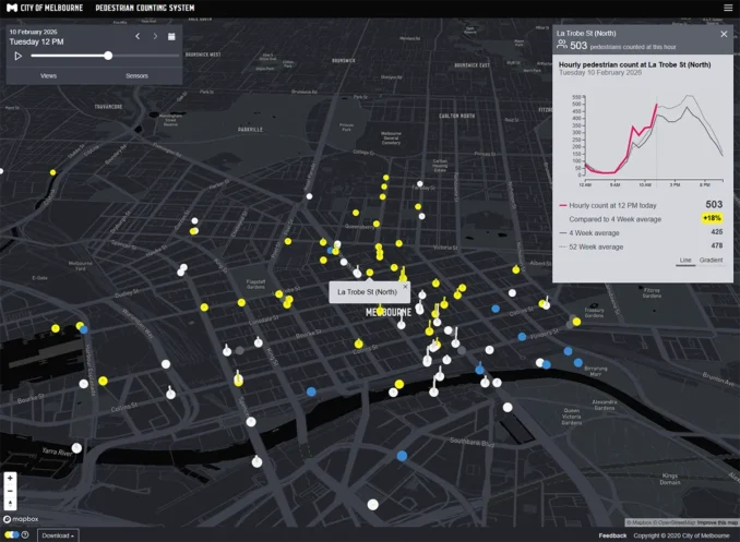
Also, there has been an increase in the use of sensors and cameras to collect data (noise, air, temperature, and people movement) for analysis and evaluation (pre- and post-construction) of projects.
BIM
BIM has become part of many design firms’ workflows, from concept through construction documentation to site administration. It enables collaboration among diverse design professions to create, review, and adjust designs.
Many landscape architects do not consider BIM a good tool for design. However, over the last few years, the ability to create landscapes has improved with upgrades to software and the increased availability and complexity of tools and plugins.
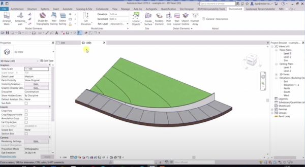
It also comes down to clients, their understanding of BIM, the intended use (clash detection, construction, facilities management), and therefore the required LOD. Not all landscape firms will utilise BIM, but over time, it has become the go-to for architectural projects, podiums/rooftops and some infrastructure (rail) projects.
Immersive AR/VR
A technology that has been used for the past 10-15 years and has improved in recent times in terms of accessibility (using phones/tablets), and that does not necessarily require a heavy laptop or computer anymore. Also, companies such as Apple and Meta are providing headsets to improve the overall experience (headset and software), they have yet to catch on beyond early adopters. Many firms will use AR/VR but many clients still prefer to have 3D models or perspectives as it can be easily viewed and discussed by many participants at once with minimal cost.
Digital Twins
A technology that became a hot topic in 2024 in the landscape architecture and AEC industries, with ongoing online discussion about its possibilities and use cases, but it appears that costs, required training, and unclear approaches and standards are hindering its adoption. There are use cases in manufacturing, traffic management, and aerospace, and I feel that the construction industry will more broadly adopt digital twins when the entry and application costs come down to a point that provides an ROI for cities, developers, and construction companies.
3D Physical Modelling
When we think of 3D modelling, we often think of small-scale machines that have become commonplace in design firms over the past 5-10 years, or of people cutting out cardboard or foam by hand or machine.
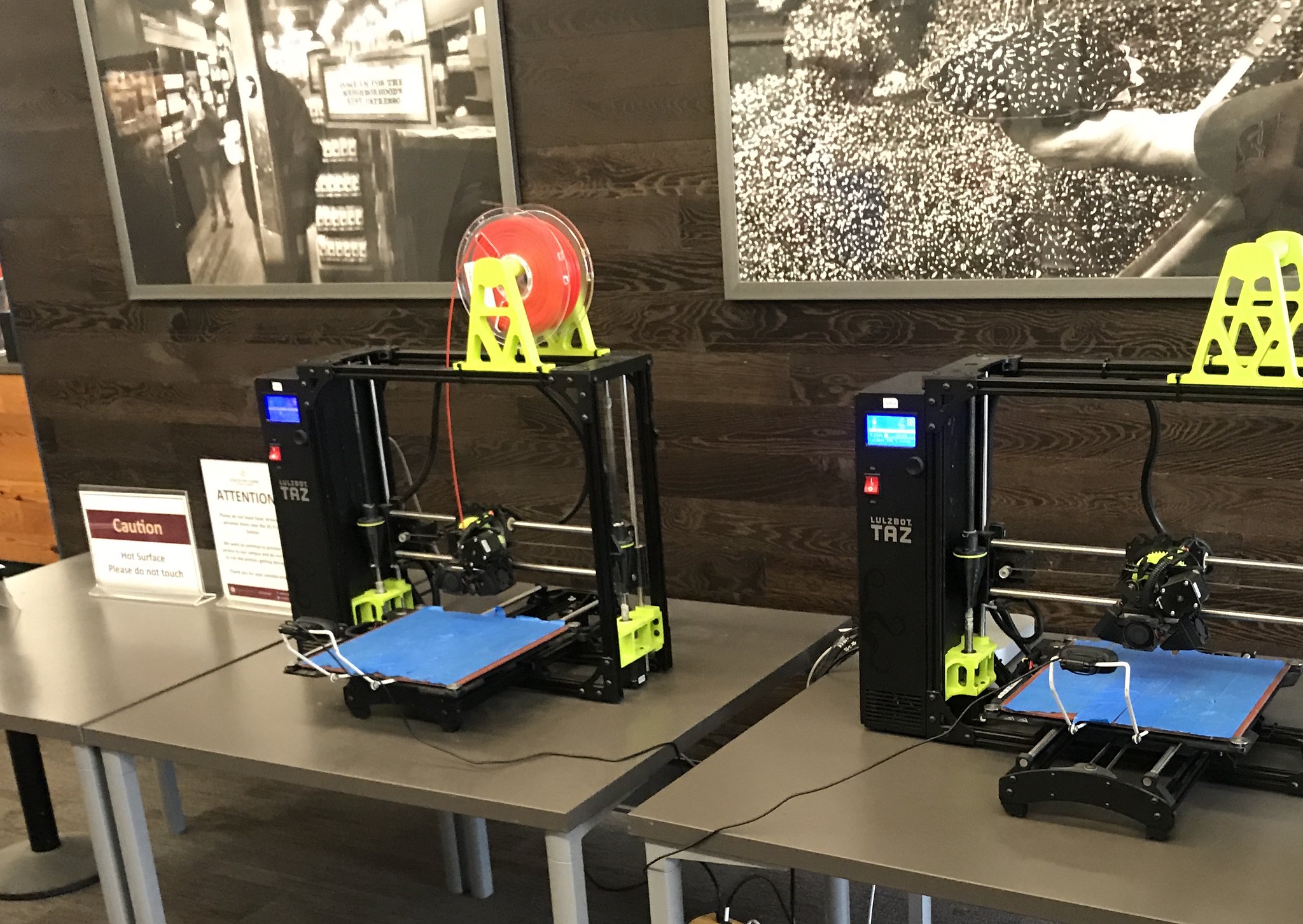
There are two types of 3D physical modelling: additive (3D printers, injection moulds, cast moulds) and subtractive (CNC machines). We have seen 3D printers grow in size and capability to the point where they can now print furniture, walls, swimming pools and buildings. Also, CNC machines are used to create small models, prototypes, and final products, including water features, sculptures, and other landscape elements.
These tools and methods are useful for landscape architects to create physical scale models, rapid prototypes, and final construction objects. Equipment costs can range from inexpensive to prohibitive for landscape architects; therefore, finding good service providers is key.
Collaboration
Even 5 years after COVID, many people still prefer to work from home, which requires effective collaboration tools. The ability of multidisciplinary teams to collaborate is easier than ever, thanks to video conferencing software (desktop/mobile), virtual whiteboards, 3D (federated) modelling, and project management platforms.
IT Infrastructure (stack)
Many firms are using a server, cloud, or hybrid approach (physical servers with cloud backup) with an Ethernet or commercial Wi-Fi network. There has been an increase in cloud use; the main issue many firms face is the number of cloud/software (Adobe/Autodesk, etc.) platforms they have to track and maintain, which increases business and administrative costs. This will only increase with collaboration and AI platforms.
Construction & Maintenance
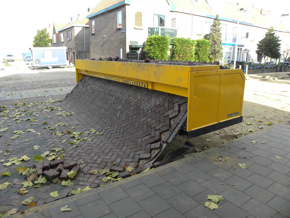
Several machines have increased construction efficiency, including concrete wall and kerb extrusion, vacuum systems for placing soil and mulch, paver-laying machines, and CNC machines for stone cutting. These technologies have improved efficiency and safety by reducing the physical stress on landscape workers.
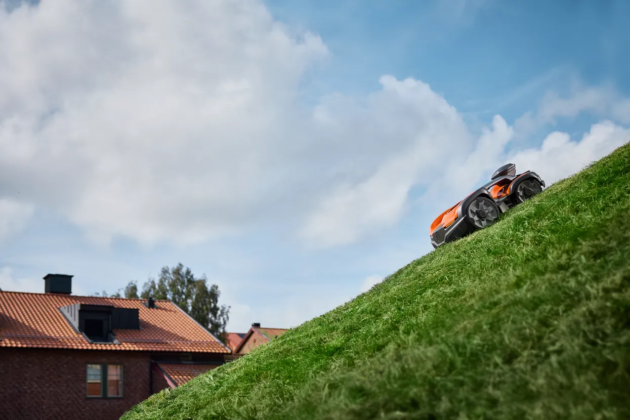
The use of technology for maintenance has increased recently, including robotic mowers, snowblowers, and drone sprayers. This use of technology is important for improving workers’ health and safety.
Technology Changing Landscape Architecture
Technology can often be controversial (AI, Robotics, etc.). There is a tendency to take a contrary view without considering the potential to improve designs and associated processes. There are often pros and cons to new technology, but how you apply them is up to each landscape architect and firm.
Landscape architects need to continually adapt whilst remaining grounded in the discipline’s principles, and realise that technology can improve their processes and that they can determine how to apply it. As I often say, I feel that many people see technology as a choice between this (old/preferred method) or that (new/technology method), rather than as a hybrid (this and that) approach.
Technology in Landscape Architecture was written by Damian Holmes, Editor & Founder – World Landscape Architecture (WLA) – First published February 13 2023 and updated February 10, 2026.